Cerulean empowers ocean pollution watchdogs with orbital observation
Reading Time: 4 minutesThe vastness of the ocean allows polluters to evade detection in all but the most egregious violations. SkyTruth aims to change that with Cerulean, an orbital monitoring platform for coastal waters that spots not just oil slicks but also the ships that produce them faster and with more certainty than ever before.
The nonprofit organization has been around for more than 20 years, acting as a watchdog and advocate in situations like oil spills and conservation efforts. Satellite imagery has always been helpful in such cases, but it was only recently that the frequency and quality of the data started becoming good enough to apply in close to real time.
Though we’re still a ways off of detecting an oil spill or leak the moment it happens, many areas of Earth are imaged multiple times per day or even per hour in extremely high definition. This data could help pinpoint the time and extent of an oil leak from an offshore drilling operation before it spreads too far.
Cerulean is the software platform they’ve built to ingest and analyze orbital imagery and other data both to identify and catch polluters and to provide improved estimates of pollution in waters around the world.
This kind of data is difficult to get straight from official sources, since they in turn rely on reports of vessel activity and other indirect metrics. Establishing the existence of a spill, dumping, or other illegal activity in the first place is hard enough, but to clearly state its magnitude is harder, and to assign responsibility is harder still.
But with satellites watching and Cerulean analyzing, the problem and its producer can be positively identified sometimes in a single image.
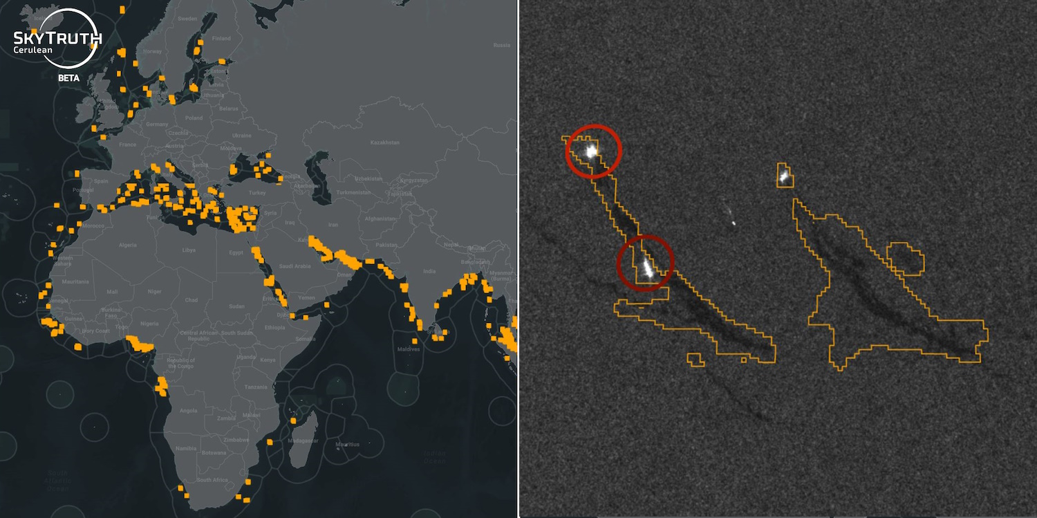
The platform looks not at the visual spectrum, but at synthetic aperture radar data, which is able to detect differences in textures on the surface — like the difference between oil and water. Cerulean’s makers built a machine learning model that identifies any suspicious slicks or trails, and then allows users to rewind and find vessels that were pinged nearby at the time.
It’s easy to use; I found a slick and the vessel that almost certainly left it behind in about 30 seconds. You can try it here yourself — just be aware it’s ‘in beta,’ like so many things.
Of course, natural oil seeps, turbulence, shadows, and other innocuous activity can look a bit like oil slicks. And not all vessels — perhaps not even a majority of vessels — are persistently tracked via their beacons, as Global Fishing Watch found out. (Perhaps not surprisingly, the two organizations work with one another.)
This means that Cerulean isn’t a solution in itself but a tool to be used in conjunction with others, and with human supervision. But even non-experts can use it, they point out, and the data is compelling without any kind of academic or advocacy trappings.
For instance, in a study conducted in 2022, SkyTruth pointed out that European authorities confirmed reports of 32 oil slicks of human origin. But based on the satellite data, they believe the number is probably a hundred times higher — 3,000 or so. Similarly, it was once estimated that about half of oil slicks are natural. A SAR study suggested it’s more like 6%. When the estimates are off by orders of magnitude, it does make you think!
This week, SkyTruth is publishing five case studies, short reports about recent projects with advocacy groups around the globe. Here’s what they’ve been getting up to:
- The Interamerican Association for Environmental Defense has been using Cerulean to monitor deep-water drilling infrastructure for leaks and spills. They hope to create daily alerts for fishermen, who not only are at direct health risk from slicks, but also catch fewer and unhealthy fish as well. ‘We’re trying to fill an information gap to pursue litigation that will help communities go after compensation for the harm caused by these spills,’ said the group’s attorney, Santiago Piñeros Durán.
- The Indonesia Ocean Justice Initiative is hoping to quantify and improve accountability for the very frequent spills in Indonesia. The nation’s highly active maritime sector, according to Cerulean data, produces as many oil slicks as the next five countries combined — over 100 per year on average. With facts like these, IOJI and others working toward change in the country’s regulatory structure will have something to point to in court.
- Runner of a small Indonesian resort, Andrew Dixon uses Cerulean to monitor the coast off of Bintan, where — lucky for him — there haven’t been any major spills in a decade. But the next time there is one, or even a persistent small one, he’ll see it and report it. ‘Being able to match a spill to a ship’s traffic is amazing,’ he said. ‘In the past, this has been a laborious process, but now it’s all automated. Just letting captains know they are being watched is powerful.’
- U.K. climate advocacy organization Uplift used Cerulean data to look at the frequency and size of oil spills affecting the country’s waters. It’s obvious that leaked or spilled oil harms wildlife, but the scale of the harm depends on the scale of the spills. ‘By mapping oil slicks hundreds of miles offshore, SkyTruth helped us quantify and visualize the harm being caused and strengthen the case for an end to new oil and gas production in the North Sea,’ said Uplift’s Daniel Jones.
- The 2022 report cited above regarding bilge dumping (32 vs. 3,000 slicks) exposes the actual scale of this problem, which is a necessary step to creating new practices and regulations around it.
Cerulean is a work in progress — though you can use it today, it’s being iterated on constantly. CTO Jason Schatz noted in response to my questions that the model itself is being improved, but that users who want to avoid false positives should restrict it to high-confidence identifications. And it’s strictly based on orbital observation and ship beacon data — no one goes out in a dinghy and makes sure it’s really oil.
‘We have manually inspected satellite imagery at several hundred locations,’ he pointed out, though. ‘We can never be perfectly confident of the composition of a slick using satellite data alone, but it is the best we can do at scale.’
This scale of visibility is indeed only available via satellite, and via the machine learning models that turn reams of data no human has time to analyze into usable analyses. SkyTruth’s plan for 2024 is to improve Cerulean with the improved model Schatz mentioned, an interface for users to set up alerts for new slicks, more training and feedback sessions with partners, and of course more work with concerned organizations and individuals. You can keep up with SkyTruth here.
Ref: techcrunch
MediaDownloader.net -> Free Online Video Downloader, Download Any Video From YouTube, VK, Vimeo, Twitter, Twitch, Tumblr, Tiktok, Telegram, TED, Streamable, Soundcloud, Snapchat, Share, Rumble, Reddit, PuhuTV, Pinterest, Periscope, Ok.ru, MxTakatak, Mixcloud, Mashable, LinkedIn, Likee, Kwai, Izlesene, Instagram, Imgur, IMDB, Ifunny, Gaana, Flickr, Febspot, Facebook, ESPN, Douyin, Dailymotion, Buzzfeed, BluTV, Blogger, Bitchute, Bilibili, Bandcamp, Akıllı, 9GAG